
This driving trail gives a flavor of the area’s Revolutionary history and is a project of the Spartanburg County 250 Committee in conjunction with the Spartanburg County Historical Association. Some short hikes are involved, so dress in comfortable shoes and clothes to enjoy every location on the tour.
In 1778, around the midpoint of the American Revolutionary War, the British shifted their focus to the southern colonies, known as the Southern Campaign. In South Carolina, the Spartan Regiment was a key player in the American Revolutionary War, engaging in many important battles.
Spartanburg County was named after the Spartan Regiment, whose brave men and women were instrumental in the fight for independence. On Col. John Thomas’s flintlock stock — the commander of the Spartan Regiment — was a silver 13-point star representing the 13 colonies (as seen in the photo and logo on the front), inscribed with:
“United States We Are One”
These five words demonstrated commitment and indomitable spirit to our newly formed country.
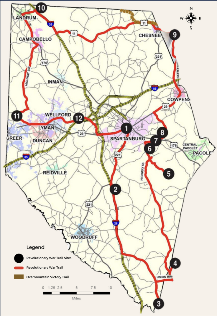
1. DANIEL MORGAN MONUMENT
Morgan Square, 148 W. Main St., Spartanburg 29301
Statue GPS: 34.949377, -81.933086
As one of the original 13 colonies, South Carolina played a pivotal role during the American Revolution. After the surrender of Charles Towne in May 1780, western South Carolina became a hotbed of activity as Patriot militia from across the region gathered to oppose the British and their Loyalist allies. The area that became known after the Revolution as Spartanburg saw numerous battles during this time, including some of the most significant battles in the Southern Campaign of the Revolution.
2. WALNUT GROVE PLANTATION
1200 Otts Shoals Road, Roebuck 29376
Near Exit 28 on I-26
Sign GPS: 34.840117, -81.968733
Walnut Grove Plantation, home of Charles Moore, was also the childhood home of Kate Moore Barry, who aided Gen. Daniel Morgan prior to the Battle of Cowpens, and Kate’s younger brother, Thomas Moore, who fought there. Walnut Grove Plantation also served as a gathering place for local militia. Walnut Grove is operated by the Spartanburg County Historical Association. The home and grounds are open to the public seasonally, and staff is available for tours. The site includes a picnic shelter, restrooms, and gift shop.
3. BATTLE OF MUSGROVE MILL STATE HISTORIC PARK
398 State Park Road, Clinton 29325
On the right in the pull-off just across the Enoree River Bridge on Highway 56
Sign GPS: 34.593000, -81.849383
In August 1780, 200 Patriot militia left their camp on the Broad River and rode under the cover of darkness to surprise an equal number of Loyalist militia camped at Musgrove’s Mill on the south bank of the Enoree River. The Patriots lured the British into an ambush, resulting in a significant victory and setting the stage for the Battle of Kings Mountain in October. The state park features interpretive trails, a visitor center, restrooms, and full-time staff.
4. THE BLACKSTOCK BATTLEFIELD
599 Monument Road, Enoree 29335
Half-mile beyond Palmetto Trail parking area and kiosk
Sign GPS: 34.679300, -81.811050
In November 1780, Gen. Thomas Sumter and several hundred men under his command stopped on the hills overlooking the Tyger River at Blackstock’s Plantation to face Lt. Col. Banastre Tarleton as they approached. Using their superior numbers, the height of the hill they occupied, and the protected cover of Blackstock’s outbuildings, Sumter defeated Tarleton. The site features an information kiosk, parking, a battle monument, and a spur of the Palmetto Trail along the Tyger River.
5. THE BATTLE OF KELSEY CREEK
450 Croft State Park Road, Spartanburg 29302
Half-mile hike along Foster Mill Trail Loop near the bridge
Sign GPS: 34.863314, -81.840449
In the spring of 1780, a group of Loyalists advanced on the home of the Thomas family near Kelsey Creek, which was storing Patriot gunpowder and guarded by Capt. John Thomas, Jr. and two dozen others. Learning of the Loyalists’ approach, Thomas removed the powder and left a few family members behind to create a diversion. Their steady fire from the house forced Loyalists to withdraw without the gunpowder. The Thomas home site is located near the junction of Fairforest Creek and Kelsey Creek inside Croft State Park. The exact location is not safely accessible.
6. THE BATTLE OF CEDAR SPRING
Below Cedar Springs Baptist Church
140 Cedar Springs Place, Spartanburg 29302
Sign GPS: 34.909528, -81.876000
In July 1780, a small force of Patriots gathered under Col. John Thomas, Jr. near Cedar Spring. The British made plans to attack the camp in a nighttime raid, but Thomas’s mother, Jane, heard of it and alerted her son. Thomas and his men prepared an ambush near their camp and opened fire on the British, killing and wounding many and scattering the survivors. The spring is on land owned by the South Carolina School for the Deaf and the Blind near the Palmetto Trail.
7. THE BATTLE OF THE PEACH TREES
Near the intersection of Dogwood Club Road and Old Petrie Road, Spartanburg 29302
Across from 680 Delmar Road
Sign GPS: 34.924633, -81.862750
Continuing their attempts to control the region, British forces under Maj. Patrick Ferguson were in pursuit of several hundred Patriots under Cols. Elijah Clarke and Isaac Shelby. In August 1780, Ferguson detached a small group to attack the Patriots who occupied a peach orchard near Cedar Spring. The British were repulsed after savage, up-close fighting. Clarke and Shelby feared a follow-up attack and retreated north toward Lawson’s Fork Creek.
8. THE BATTLE OF WOFFORD’S IRON WORKS
103 Emma Cudd Road, Spartanburg 29302
Sign GPS: 34.941767, -81.840133
After the Battle of the Peach Trees, Cols. Clarke and Shelby retreated north to avoid another confrontation with Maj. Ferguson. He caught them at Wofford’s Iron Works on Lawson’s Fork Creek but couldn’t successfully engage because the Patriots were mounted. The Patriots continued their retreat and the British returned to their camp at Cedar Spring. This running battle is referred to by several names, including “Second Cedar Spring,” “The Battle of the Peach Trees,” and “The Battle of Wofford’s Iron Works.” The precise sites aren’t known since the iron works were destroyed in 1781.
9. THE BATTLE OF COWPENS
4001 Chesnee Highway, Gaffney 29341
Parking about a mile past the park entrance at Highway 11 and Hayes Road
Sign GPS: 35.131067, -81.797067
In December 1780, Gen. Daniel Morgan moved a veteran force of American Continentals and militia into the area west of the Broad River in modern-day Spartanburg and Cherokee counties. British Commander Lord Cornwallis sent Lt. Col. Banastre Tarleton to counter the threat. On January 17, 1781, Morgan stood against Tarleton at Cowpens. The resulting battle was a complete victory for the Patriots and stands as one of the most significant events in American history. Cowpens National Battlefield includes a visitor center, interpretive trails, an auto tour, and full-time staff.
10. THE BATTLE OF EARLE’S FORD
Highway 14 east of Exit 1 on I-26, Landrum 29356
Near the Pacolet River Bridge
Sign GPS: 35.190191, -82.143031
In July 1780, a small group of Loyalists under Capt. James Dunlap left their post at Fort Prince to attack Patriots on the north side of the Pacolet River near Earle’s Ford. Arriving early in the morning on July 15, Dunlap and his men crossed the lightly guarded ford and surprised the Patriots closest to the river. The remainder of the camp formed for battle, and Dunlap retreated after realizing he was badly outnumbered.
11. WOOD’S FORT
1904 Gap Creek Road, Greer 29651
Intersection of S.C. 908 and Highway 357
Sign GPS: 34.971467, -82.199800
The American Revolution provided an opportunity for pre-war conflicts and disputes to come to the surface in sometimes brutal ways. One such incident occurred in July 1776 when a party of Loyalists and Cherokees raided the Hampton home near the Middle Tyger River, killing several family members before the survivors fled to Wood’s Fort. The fort was built to protect colonial families during warfare with the Cherokee Nation allied with the British and was re-fortified in 1780.
12. THE BATTLE OF FORT PRINCE
Off Fort Prince Road, Wellford 29385
In the vicinity of the 350 block of Fort Prince Road
Sign GPS: 34.964185, -82.050390
Following the British attack at Earle’s Ford, a small group of Patriots under Capt. Edward Hampton pursued Capt. James Dunlap. Hampton caught Dunlap and began driving him and his men toward the British-held post at Fort Prince. Upon reaching the outskirts of the fort and its 300 British soldiers, Hampton and his men withdrew. Fearing an attack by a larger Patriot force, the British soon abandoned Fort Prince. The fort was one of several pre-Revolutionary forts built near the Indian boundary line, now the Greenville–Spartanburg county line.